Retail and the Livable City, Part 2
Retail contributes to city vitality, character, and livability, as well as the city’s economy. Retail faces many challenges, but San Francisco can help local grow and thrive. In Part 1, we talked about rising rents and vacant storefronts, fostering a diverse and complementary mix of uses, and how good buildings make good retail districts. Here in Part 2, we explore how complete streets, sustainable transportation, and better planning can help retail thrive.
Enhancing walkability
Retail and walkability have a symbiotic relationship. A robust retail sector makes neighborhoods more walkable, and enhancing walkability helps retail thrive. Walkability depends on both the design of buildings, as discussed in Part 1, and the design of adjacent streets and sidewalks. Badly-designed buildings can make even the best-designed public realm uninviting, and badly-designed streets can erode the vitality of neighborhoods with good buildings.
According to renowned Danish architect and urban designer Jan Gehl, city streets traditionally serve three broad purposes – meeting, movement, and marketplace. Until recently, San Francisco’s traffic engineering bureaucracy favored automobile movement over walkability, bikeability, and greening. Sidewalks were narrowed on streets designated as traffic channels, and streets in neighborhoods like SoMa, Downtown, the Tenderloin, and Western Addition were converted to one-way roads to increase the speed and volume of through traffic. Turning multi-functional neighborhood streets into traffic sewers has badly eroded neighborhood livability and street safety, and battered neighborhood-serving businesses.
The 2006 Better Streets policy reestablished a multi-functional, multi-objective, and multi-modal approach to streets as City policy. The 2010 Better Streets Plan developed a set of street types based on the character of the community – residential, commercial, or industrial – replacing the prior classification based on a street’s traffic function (arterial, collector, or local street). It developed standards for streets of each type, including a minimum and optimum sidewalk width, safety and accessiblity features like curb extensions at intersections, and furnishings like street trees, planting basins, lighting, and seating.
Subsequent legislation, which Livable City wrote and championed, requires that large developments improve adjacent sidewalks in accordance with the Better Streets plan or neighborhood streetscape plans. The Better Streets Policy and Plan are a good start, but the City hasn’t taken the necessary steps to fully implement its plan. The city never mapped which streets are of which type, never catalogued which streets were deficient per its standards, and never developed a plan to bring deficient streets up to current standards.
Deficient sidewalks – too narrow, and in need of repair – are a common problem on San Francisco’s retail streets. Insufficient sidewalk lighting, lack of street trees, and poor maintenance and cleanliness are other common problems.
Making streets more attractive to pedestrians and calming traffic creates healthier retail districts. Anecdotal evidence supports this, and it’s conventional wisdom among retail and economic development experts.
New York City’s transportation department conducted one of the most rigorous studies of this relationship. It assessed economic health, as measured by retail sales, before and after streetscape improvements were installed, and compared the improved streets to otherwise similar streets where no improvements were made. The study found that six corridors with streetscape improvements, including projects that established bikeways and transit-priority lanes, had significantly higher retail sales than the comparison neighborhoods and the borough as a whole.
San Francisco’s various public agencies have begun paying more attention to sidewalk safety, access, and amenities. Projects like the Better Valencia project, which widened and greened Valencia Street’s sidewalks between 15th and 19th Street, and the widened sidewalks on Castro Street between Market and 19th, are good examples of what’s possible.
However projects like Castro and Valencia are the exception, and only came about because they had influential and persistent champions in both the community and in City government. Typically City agencies approach streets projects piecemeal, and spend many millions of dollars each year rebuilding inadequate and unsafe streets just as they are. A Complete Streets approach would transform San Francisco for the better, and better coordination among agencies would save money, reduce construction disruption, and leave the City a better place.
The City’s maintenance and cleanliness practices also need improvement. We supported Proposition E on the November 2016 ballot, which established secure funding for City maintenance of street trees. Some commercial areas have established Community Benefit Districts (CBDs) to provide cleaning and other street services. We like what many of the CBDs are doing, including activities go beyond the basics, but it ought not require creation of a special entity to ensure that basic city services get delivered consistently.
Parking and loading
Managing the curb – street parking, passenger and goods loading, and improving safety and accessibility for transit riders, pedestrians, and cyclists – supports vital commercial districts and livable neighborhoods.
In retail corridors, good parking management means ensuring that parking spaces turn over in the course of the business day, favoring retail customers over long-term parkers. Typically the city encourages turnover with parking meters and time limits. The City’s innovative SFpark program uses variable meter pricing to maintain parking availability during meter hours in six commercial districts, which increases convenience and reduces traffic congestion and traffic danger from circling and double-parking.
In December, SFMTA voted to extend the successful SFpark program citywide. However in many neighborhoods, peak demand for curb parking is in the evening hours and on Sundays and holidays, when SFMTA doesn’t charge at meters or enforce time limits. Businessses active during those hours suffer from the lack of parking turnover, and traffic congestion and parking spillover on evenings and Sundays reduces safety, mobility, and livability in commercial districts and adjacent residential neighborhoods.
The city has been less successful at managing curb loading. Businesses depend on curb loading for deliveries. The proliferation of ride-sharing services like Uber and Lyft, along with an increase in delivery vehicles from internet retailers and food delivery services, has increased the demand for curb loading, but SFMTA has designated very few loading zones, and does little enforcement of illegal parking and loading. The result is rampant double-parking, and parking and loading and bus zones and crosswalks. Increasing the number of loading zones and extending loading zone hours are increasingly critical in the City’s commercial districts.
Managing parking to increase availablity and reduce traffic congestion and illegal parking is important, but San Francisco’s commercial districts depend more heavily on sustainable transportation – walking, cycling, and public transit – than many realize. The SF Transportation Authority’s 2014 parking supply and utilization study surveyed the travel behavior in commercial corridors – Cow Hollow, West Portal, Hayes Valley, and Bernal Heights. The study examined parking availability, parking turnover, and parking duration, and interviewed merchants and residents.
While merchants in the four neighborhoods thought that 72% of their customers “drove exclusively” to the neighborhood, in fact over 70% of their customers walked, cycled, or took transit. It also found that both businesses and residents were willing to pay more for parking in return for greater parking availability. Shoppers weighed personal safety around where they park among their top concerns, and nearly as importantly as availability of parking, which underscores the importance of active street-facing uses and investments like sidewalk lighting.
A more recent survey (March 2017) of shoppers on Geary Boulevard between Market and Stanyan streets found that about 55 percent of those surveyed arrived at Geary Boulevard by transit, and 35 percent arrived by walking — a total of 90 percent. Only 6 percent arrived by car.
Retail-friendly streets
Creating streets that foster healthy retail districts and livable communities often means rethinking traffic speed, traffic volume, and one-way streets. On many San Francisco streets, retail vitality and neighborhood livability has been sacrificed to commuter traffic. Widening sidewalks, and allocating more space for sustainable transportation, may mean fewer travel lanes, or narrower ones. Slowing auto traffic is the most effective strategy for reducing traffic deaths and serious injuries, and reduced traffic speed benefits retail districts in other ways – slower traffic speeds allow drivers to notice local businesses, and lower speeds make it possible to park.
Multi-lane one-way streets are also bad for business. More and more studies are finding that businesses on one-way streets do poorly relative to those on otherwise comparable two-way streets, and smart cities across the country are restoring two-way traffic to revitalize commercial districts. Two-way streets also improve the legibility of transit and bicycle networks, and make it easier to access parking spaces.
Car-free shopping streets are common in cities around the world, but they’re relatively rare in the US. Successful pedestrianized streets require several conditions for success. There need to be rich sustainable transportation options – public transit, cycling, and walking. The area needs to be a compelling and distinctive destination – distinguished buildings, and high-quality public places. The mix of uses needs to be diverse and generate street activity 18 hours or more each day – residents, workers, hotel, cultural facilities, shops, eating and drinking establishments, and entertainment. Car-free streets need active management and programming of activities. A number of neighborhoods in San Francisco have the right mix of character, access, and activities to make car-free streets work. The City’s Powell Streetscape Project proposed expanding the sidewalks on lower Powell Street, preserve a cable car right-of-way, and limit automobile access to passenger loading and deliveries. The City’s Better Market Street project proposes removing private cars from Octavia Boulevard to the Embarcadero, and redesigning the street for better walking, cycling, and public transit. Both projects integrate pedestrian-scaled lighting and handsome new paving.
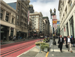
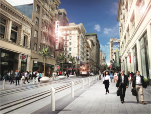
Powell Street, existing and proposed. Photos courtesy SFMTA.
Streets can be car-free on a temporary basis – for Sunday Streets, street fairs, and festivals, or at certain times of day. Design details like handsome roadway pavements, curbless single-surface streets (with bollards and/or textured paving to preserve pedestrian and disability access), pop-up bollards, or swinging gates like those on Portland’s Festival streets create high-quality people-oriented spaces when streets are closed, and calm traffic at all other times.
Retail and the Livable City
To sustain healthy, locally-owned, and neighborhood-serving retail businesses, San Francisco needs a coherent retail strategy, tied to San Francisco’s other strategic goals – a diverse and equitable local economy, livable neighborhoods, sustainable mobility, and ensuring residents’ and businesses’ access to necessary goods and services.
City and state law mandate that the City’s General Plan be “an integrated, internally consistent and compatible statement of policies for San Francisco”, and address land use, transportation, environmental sustainability, economic development, health, public safety, in a coordinated way, and ensure that the city’s various policies complement one another.
San Francisco’s General Plan falls short in several regards. It is missing the required land use element, and other elements, like transportation and commerce and industry, are badly out of date. New state guidelines for general plans require that they address both equity and sustainability, and recommend both walkable communities and healthy communities strategies to meet the state-mandated objectives. Our General Plan doesn’t explicitly embrace walkable communities, and addresses equity and sustainability only tangentially.
Neighborhood Planning is another way to integrate retail into an overall strategy for housing, transportation, and streets and open spaces at neighborhood scale. San Francisco created several neighborhood plans a decade ago, but has committed to only one neighborhood plan since then, and left two neighborhood plans a decade ago.
San Francisco doesn’t have good data gathering and analysis about the state of retail – square footage, uses, rents, vacancies, and so on.
Much of San Francisco’s retail is in walkable neighborhoods, but the City does have some large car-oriented malls and strip shopping centers. Shopping malls are overbuilt and in decline across the US, with up to a quarter of the country’s malls are predicted to close within the next five years. San Francisco isn’t immune. Oceanview Village shopping center on Alemany Street is mostly empty, and Macy’s is closing its anchor department store at Stonestown Mall. The 6×6 mall on Market Street, which was granted excess parking by the Planning Commission even though it is located on Market Street next to a Downtown BART station, sits completely empty. Last year saw big-box retail and department store chains close hundreds of stores, and it looks as though the trend will continue in 2018. In recent years more national retail chains have opened ‘urban format’ stores – located in walkable neighborhoods, with smaller footprints and little or no parking. Trader Joe’s and Target opened stores on 4th Street downtown in mixed-use buildings with no parking.
Other cities have redeveloped dying malls as walkable neighborhoods, creating a network of human-scaled streets and blocks, and replacing parking lots with a mix of housing and offices with some ground-floor shops arranged along retail streets. In a City where land is expensive and scarce, encouraging the redevelopment of shopping centers and their parking lots creates suitable sites for needed housing and establishing walkable communities along transit corridors.
Recently the City approved a 500,000 square-foot auto-oriented outlet mall on the former Candlestick stadium site, highlighting the City’s misplaced priorities. The City should instead use these 13 acres for housing, and focus on growing a local-serving, walkable commercial district nearby along Third Street in the Bayview, where the City invested hundreds of millions to build a light-rail line, and where there are still many vacant storefronts and sites well suited to housing over neighborhood-serving retail.
Action Plan
High rents and vacancies
- increase financial penalties on building owners for keeping retail spaces vacant long-term.
- expand assistance for legacy businesses, including helping businesses buy their buildings.
- provide assistance to workers seeking to convert businesses to worker-owned cooperatives.
- expand business incubators.
Getting the right mix of uses
- Remove the one-third maximum for accessory arts uses in mixed-use zoning districts, and permit arts uses above the ground floor.
- Expand the healthy corner store program.
- Encourage stores selling affordable healthy food in neighborhoods that need them, through both zoning changes and direct financial and technical assistance.
- Remove the one-third maximum for accessory production in Commercial, Residential-Commercial, and Mixed-Use zoning districts.
Diverse and high-quality retail spaces
- Require that large commercial developments include some smaller storefronts.
- Extend the 5′ height bonus for tall commercial ground floors in new buildings to all zoning districts.
- Allow buildings being retrofitted to be raised to create a tall ground floor.
- Expand City support – loans, small grants, and design and technical assistance – for facade improvements and signage upgrades.
Enhancing walkabilty
- Create a complete streets program for commercial streets which includes wider and better sidewalks, pedestrian crossings, street trees, and seating.
- Adopt sidewalk lighting standards which light sidewalks well while preventing light trespass into residences.
- Require that new or renovated commercial buildings provide building-mounted sidewalk lighting.
- Create a street lighting strategy for the City.
Parking and loading
- Improve curb management, including getting the price of curb parking right and designate more space at more times for passenger and goods loading.
- Extend parking meter hours to Sunday and into the evening hours in commercial districts where parking demand at those times is high.
Retail-friendly streets
- Redesign high-speed neighborhood streets for slower speeds.
- Restore two-way traffic to multi-lane one-way steets.
Retail and the Livable City
- Establish walkable neighborhoods as a cornerstone strategy in the City’s General Plan.
- Create a Land Use element in the City’s General Plan, with a strategy for walkable retail districts.
- Rationalize the system of zoning districts to foster walkable retail districts with complementary uses.
- Improve data gathering about neighborood retail – uses, square footage, rents, vacancies, etc.
- Encourage new housing above and within walking distance of retail corridors.
- Relax zoning controls to allow neighborhood-serving retail and retail districts to grow in corridors and neighborhoods, like Twin Peaks and along M-Ocean View streetcar line, where neighborhood-serving retail is currently lacking.
- Encourage the redevelopment of automobile-oriented retail – strip commercial, shopping malls, and big-box retail centers – as walkable mixed-use neighborhoods, with a pattern of human-scaled streets and blocks.