Planning for a Livable City
To a casual observer, San Francisco appears to be struggling with linked crises – unaffordable housing, dysfunctional transportation, growing inequality, aging and inadequate infrastructure, and financial and ecological unsustainability – with no real plan. Look a little closer, and you’ll find that the City has many official plans and many ongoing planning efforts, and numerous planning agencies. Look even closer, and you’ll find that these plans are of varying ages and degrees of completeness, and some are badly out of date. Many of those plans are not being implemented, and some are not even implementable.
You have to look very closely, because the City’s plans, and the roles of various City agencies in planning and in implementing plans, are not legible or transparent. Plans and planning roles have developed ad hoc, with both significant gaps and significant areas of overlap, and even areas of conflict. Increasingly, large projects are ‘spot-zoned’ with project-specific zoning controls negotiated between the Mayor’s office and developers, mostly bypassing the Planning Department, adopted plans, and Planning Code. The proliferation of spot-rezoning and ‘planning by exception’ are clear signals that the City’s planning apparatus is broken – the City’s planners are increasingly reacting and not anticipating, and political and popular confidence in planning has eroded.
How did a great city, which officially extols the values of livability, equity, sustainability, transparency, and accountability, get to such an impasse? City government spends millions of dollars each year on planning, and has dozens of planners in several planning agencies. The answers are historical and complex, and there has been little official leadership in sorting out the various plans and various planning fiefdoms for the benefit of San Franciscans. San Francisco’s proliferation of planning agencies may by part of the problem.
Livable City believes that integrated, rigorous, values-driven, transparent, and accountable planning can help San Francisco achieve its goals, and realize its values – livable neighborhoods, green and safe streets, housing for all, sustainable mobility, greater health, happiness, and equity, and accountable and transparent governance.
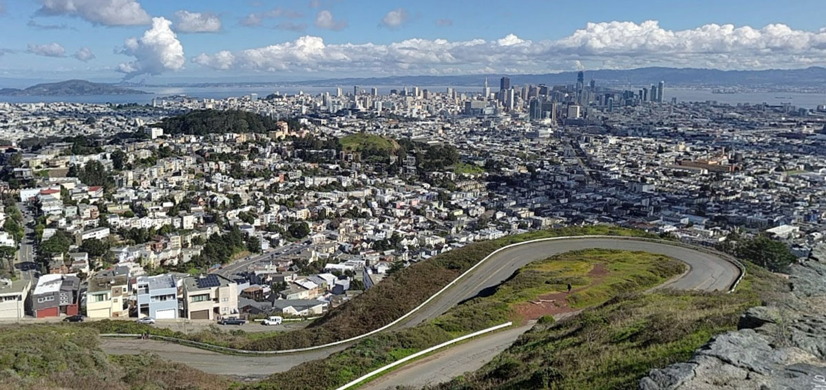
With just 47 square miles, San Francisco needs thoughtful planning for how to use limited space – making room for new housing without displacing existing residents; creating new and expanded green open spaces, community gardens and farms, and home for San Francisco’s globally-recognized biodiversity; and space for neighborhood-serving businesses, arts and artists, nonprofits and community institutions, offices, and essential production and light industry. We increasingly understand ways in which the design of cities can combat climate change, reduce traffic congestion and enhance sustainable mobility, improve health and happiness, reduce exclusion, and foster equity and community, and our plans should reflect these understandings.
We need better planning at all scales – regional, citywide, neighborhood, block, and project. We focus here on the planning at citywide, neighborhood, and large project scales, and will cover other scales in future posts. What follows are Livable City’s recommendations for reviving the City’s General Plan, reviving neighborhood planning by undertaking new neighborhood plans and completing unfinished plans, and improving the planning and review of large projects to create more transparency and predictability for both neighbors and developers, and to more consistently secure lasting public benefits from large new developments.
The General Plan
Under California law, every city and county is required to have a general plan, and to keep it current. General plans are composed of different sections, called elements, which address particular areas – land use, circulation (aka transportation), housing, safety, etc.
Some elements are required (including land use, circulation, and housing) and others are optional. Housing elements must be updated on a state-mandated schedule. Other elements are generally required to be kept current, complete, and integrated with other elements, but don’t have prescribed timelines for updates.
The past decade has brought many changes to California’s planning laws. The state adopted targets for greenhouse gas emissions, and now requires land use and transportation planning to address both climate protection and climate change adaptation. In 2016, the state required that cities and counties integrate environmental justice into their plans, as either a standalone element, or integrated into each element and area plan as it is completed or updated.
Last year, the state updated its general plan guidelines address the evolution of California’s planning law, and to further equitable, sustainable, healthy, and livable communities. The new guidelines encompass climate change, environmental justice, housing needs, healthy communities, walkable communities, and protecting habitat and biodiversity. The new guidelines call not just for sound and integrated policies, but for rigorous analysis of equity and health disparities and strategies for lessening those disparities, as well as concrete financial and other strategies necessary to achieving the policy goals in the plan.
In 1986 San Francisco voters approved Proposition M, which requires that “the General Plan shall be an integrated, internally consistent and compatible statement of policies for San Francisco.” San Francisco’s General Plan is overseen by the Planning Department, with approval by the Board of Supervisors.
Unfortunately San Francisco’s General Plan is woefully inadequate – it’s incomplete, badly out-of-date, and poorly integrated. It doesn’t meet San Francisco’s own standards or the state requirements. It lacks a land use element, which is both required and central to organizing the other elements. Our Housing Element and Recreation and Open Space Element have been updated in recent years, but most other elements haven’t had a comprehensive update in decades.
Land Use. A Land Use element is of central importance in a General Plan, and creating a land use strategy for San Francisco is critical. As the California guidelines put it, “the most fundamental decisions in planning begin with land use: what to put where.” Since land use and transportation are two sides of the same coin. Any good planner knows that, and the State guidelines are built on that understanding. It’s impossible to plan effective transportation networks if there’s no coherent plan for where jobs, housing, and services will go. It’s also impossible to plan for housing needs without a land-use strategy.
Land use is governed by San Francisco’s complicated Planning Code, which regulates dozens of defined uses in over 100 zoning districts, as well as building features like height, bulk, yards, and so on. The Planning Code is specific, but it isn’t strategic; it’s the implementing document for a plan that doesn’t exist, and the result is a jumble of arcane and often contradictory requirements that too often run counter to the City’s stated values and goals. Land use controls are typically revised on a zoning district or neighborhood scale, and increasingly project-by-project. A citywide land use strategy must be flexible enough to accommodate neighborhood plans and individual decisions about how to use buildings and lots, and the impossibility of predicting all future conditions and outcomes. However without any citywide land use strategy, San Francisco remains in danger of losing entire communities and entire sectors of the local economy, leaving the City far less diverse and less resilient. The Land Use element should include strategies for making space for housing, regionally-connected jobs centers, neighborhood-serving retail and services, arts and nonprofits, and industry, and open space. In general, a mix of uses is desirable for fostering diversity, walkability, and opportunity. However without any limitations on uses, high-rent uses, like offices and luxury housing, typically crowd out important but less lucrative uses. Controls on which uses are allowed and in what concentrations can be a powerful tool for conserving a diversity of uses.
Transportation. The General Plan’s Transportation Element was last updated in the early 1990s. Its policies are mostly sound – supporting sustainable modes like walking, cycling, and transit, and managing parking and roads to reduce auto traffic and congestion. However the element is still in need of an update. It doesn’t address pressing issues like public transit capacity and expansion, pedestrian and bicycle safety (Vision Zero), the future of our roadways and freeways, equity and environmental justice, or climate change – automobiles are San Francisco’s largest source of greenhouse gas emissions. San Francisco also ranks among the worst in the world when it comes to traffic gridlock, coming in third behind Los Angelas and New York City, according to a recent report.
The Planning Department has currently scheduled an update to the Transportation Element starting in 2019. While the scope of the update isn’t public yet, transportation equity – both equitable access and mobility for all San Franciscans, and reducing inequitable impacts of our transportation system like pollution and traffic danger – must be rigorously addressed in it. It should also include strategies and an implementation plan for transit capacity, a freeway master plan, transportation demand management, and implementing the City’s complete streets/better streets standards.
The freeway master plan would take a comprehensive look at San Francisco’s freeway system for the first time since they it was planned in the 1940s. Our freeway network was designed as part of a massive system that would have covered the city. Citizens rejected freeway expansion during the 1959-1965 freeway revolt, when San Franciscans resisted and ultimately halted the construction of several major citywide highways. Following the 1989 Loma Prieta Earthquake, the Embarcadero Freeway was removed, along with portions of the Central (US 101) and Southern Embarcadero (I-280) freeways. San Francisco’s freeway removals inspired cities around the world to remove freeways, and more cities are preparing to follow suit.
The remnant freeway network divides neighborhoods, blights adjacent communities, and it threatens safety and accessibility at its touchdown points. The freeway system is also aging. The freeway on-and off-ramps on many segments are closer together than current standards allow, creating weaving and conflict zones. The northern ends of the Central (101) and Southern Embarcadero (I-280) freeways are stubs, never designed to terminate where they now do. A comprehensive freeway plan would guide big future investments in the freeway networks, including removing obsolete sections and replacing them with upgraded transit.
Neighborhood Planning
Livable City supports comprehensive neighborhood planning that integrates land use, transportation, public space, and sustainability. Neighborhood Plans implement the General Plan’s goals at the neighborhood scale, creating new opportunities for housing, preserving and enhancing affordability, supporting a diverse and inclusive local economy. enhancing sustainable mobility, planning for streets and open spaces, and improving the local environment and neighborhood livability.
A neighborhood plan should have four elements. The land use plan lays out the permitted land uses, and opportunity sites for housing, jobs, open space, and community institutions, and establishes a human-scaled pattern of streets, blocks, and lots where it’s lacking or has gaps. A transportation plan addresses current and future mobility needs, including walking, cycling, transit, loading, and street design, and a neighborhood-scale transportation demand management plan to manage traffic congestion in the neighborhood. A public space plan creates an interconnected system of public open spaces – sidewalks, plazas, parks, and community gardens – for the neighborhood, as well as needed public community facilities – schools, recreation centers, etc. A stabilization plan prevents the loss of existing affordable and rent-stabilized housing, and protecting residents, local-serving businesses, and community institutions from displacement.
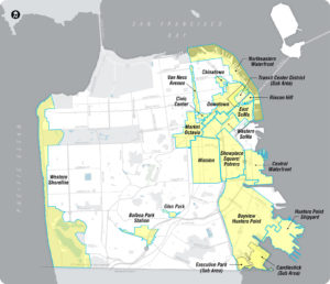
Neighborhood Plans in San Francisco
This map shows San Francisco’s existing neighborhood plans. They cover only a small portion of the city, and some, like the Downtown Plan, haven’t been updated in decades. None of the current plan areas has all four of the necessary elements – land use, transportation, public space, and stabilization.
San Francisco’s commitment to comprehensive neighborhood planning has ebbed since the Better Neighborhoods and Eastern Neighborhoods plans were adopted in 2008 and 2009. Only one new plan, the Central SoMa Plan, has begun since then. Two neighborhood plans – Japantown/Western Addition, and Bayview Hunters Point – were abandoned before their implementing controls were even adopted.
Most neighborhoods don’t have transportation or public space plans, and those that were adopted are incomplete. Some of these plans identified specific projects, typically streetscape projects. Some of these have been implemented, but many are unimplemented or only partially implemented. No City agency is tasked with ensuring that the projects identified in community plans get adopted. This needs to change. Transportation and public space plans ensure that neighborhood livability is preserved and enhanced as new development takes place, benefitting existing residents and workers as well as new ones. Transportation and public space plans ensure that impact fees, and in-kind requirements like streetscape improvements, deliver essential neighborhood infrastructure in a timely way.

Priority Development Areas in San Francisco
As part of the region’s sustainable regional growth strategy, San Francisco designated several Priority Development Areas (PDAs). PDAs, according to ABAG, “are places identified by Bay Area communities as areas for investment, new homes and job growth.” Some of these overlap with neighborhood plan areas, but many have no neighborhood plan. The PDA are concentrated on the east side of the City, with the City’s major westside transit corridors – notably Geary Boulevard and West Portal Avenue – not designated as PDAs. Every PDA should have a neighborhood plan, and all of those plans should include the four elements. PDAs should be expanded to include at least the Geary and West Portal transit corridors.
Planning Large Projects
Large projects are an opportunity to further the goals of the general plan and neighborhood plans. The City’s process for planning and approving large projects should consistently improve project quality, provide certainty and clarity, enhance urban design, provide necessary public benefits from development, and reduce negative impacts of large projects including displacement, traffic, pollution, and erosion of neighborhood character.
The large project review procedures in the Planning Code vary enormously from zoning district to zoning district. The criterion for large projects vary enormously; in North Beach, a project on a typical-sized San Francisco lot of 2500 square feet or more requires special review, but in other zoning districts height is the trigger for special review, and in others square footage, and several there’s no limit. In most zoning districts, large projects require Conditional Use authorization.
Conditional Use is typically used for uses or features that pose a potential nuisance, like liquor stores or massage establishments, and requires the Planning Commission to find that the use or feature is both “necessary and desirable”. Conditional Use an awkward tool for review of large projects, and the City established specialized design review procedures for large projects in three sets of zoning districts – Downtown, Downtown Residential, and Eastern Neighborhood Mixed Use districts. These design review procedures, and the voluntary Planned Unit Development procedure for large projects in certain other districts, permit broad exceptions from the requirements of the Planning Code, including increased height and bulk, and excess parking.
Zoning should provide a degree of certainty about what is and is not permitted, without being too prescriptive. A large project review procedure should also ensure that large new developments complement the existing neighborhood, extending a human-scaled pattern of streets and blocks with buildings that define and engage the sidewalk and, where it exists, the pattern of rear yards and mid-block open spaces. Design review can help ensure quality architecture and materials. It ought to offer some flexibility where variations from the requirements produce demonstrably better results.
Many development advocates argue for using only objective criteria, and more ‘as-of-right’ development, arguing that subjective design review only adds risk and delay to projects. Our objective standards need to improve, and as they improve we should rely more often on them. Cities are increasingly embracing form-based codes, which create predictable built results and a high-quality public realm by using physical form, rather than use, as the basis of regulation. Livable City worked to improve the City’s standards for storefront tranparency and sidewalk improvements that are now codified in the Planning Code. However it’s difficult, and probably impossible, to reduce all the architectural and urban design elements that make a good project to an algorithm which anticipates every context in a complex and varied city. There should a place for qualitative judgement in the development process, especially for large projects that represent significant additions to a neighborhood. Large projects which are not asking for exceptions or variances ought to undergo design review, but after completing design review ought not be subject to ongoing appeals.
One planning tool that San Francisco lacks, and which other cities have, is a subdivision regulation that establishes a pattern of human-scaled streets and blocks on very large sites. Human-scaled blocks, and connected networks of public rights of way, are essential to creating walkable cities, and to knitting large projects into established neighborhoods. San Francisco does have regulations in a few zoning districts which require mid-block passages, but doesn’t have the right regulations to create a network of streets, blocks, and open spaces on large sites. The City has negotiated subdivision standards on a case-by-case basis on some large projects. A subdivision regulation, with standards for maximum block sizes (excepting open space blocks) would deliver those public benefits more consistently. As we pointed out in our post on the future of San Francisco retail, several large mall sites, like Stonestown, are already being considered for incremental or complete redevelopment.
Action Plan
General Plan
- Integrate California’s General Plan Guidelines into a work plan for completing and updating San Francisco’s General Plan, including public participation.
- Create a Land Use Element of the General Plan, which includes strategies and policies for walkable neighborhoods, industrial protection, arts and nonprofits strategy, rationalized zoning districts, and environmental justice. Integrate it with the transportation, housing and other General Plan elements.
- Update the Transportation element of the general plan, with strategies and policies for transit expansion and capacity, sustainable transportation, safe and complete streets, the future of the freeway network, and equity and environmental justice.
Neighborhood plans
- Create a standard for neighborhood plans which includes land use, transportation, public space, and stabilization elements.
- Work with neighborhoods to complete the unfinished neighborhood plans – Western Addition and Bayview.
- Create the missing plan elements for neighborhood plans that are currently incomplete.
- Create neighborhood plans for each designated Priority Development Area.
- Review and update plans with community participation every decade.
Large project review
- Stop requiring Conditional Use approval for housing where housing is otherwise permitted, and stop using Conditional Use authorization as a large project review procedure.
- Create a consistent and transparent project review process for large projects – projects on large sites, or very tall projects – to successfully integrate large projects into neighborhoods for the benefit of residents and workers in the project, and to the neighborhood as a whole.
- Create a subivision standards which create a human-scaled pattern of blocks, public rights-0f-way, and public open spaces on large development sites.