
This is the first installment of three-part essay on how the Loma Prieta earthquake reshaped San Francisco.
At 5:04 pm on October 17, 1989, deep under the Santa Cruz Mountains, a 25-mile section San Andreas fault ruptured. Powerful shockwaves rippled in all directions, shaking the Bay Area and Central Coast with a magnitude 6.9 earthquake. The shaking was generally strongest near the rupture, but in some places the local geology and soils amplified the ground movement, particularly in areas where open water or wetlands had been filled by humans.
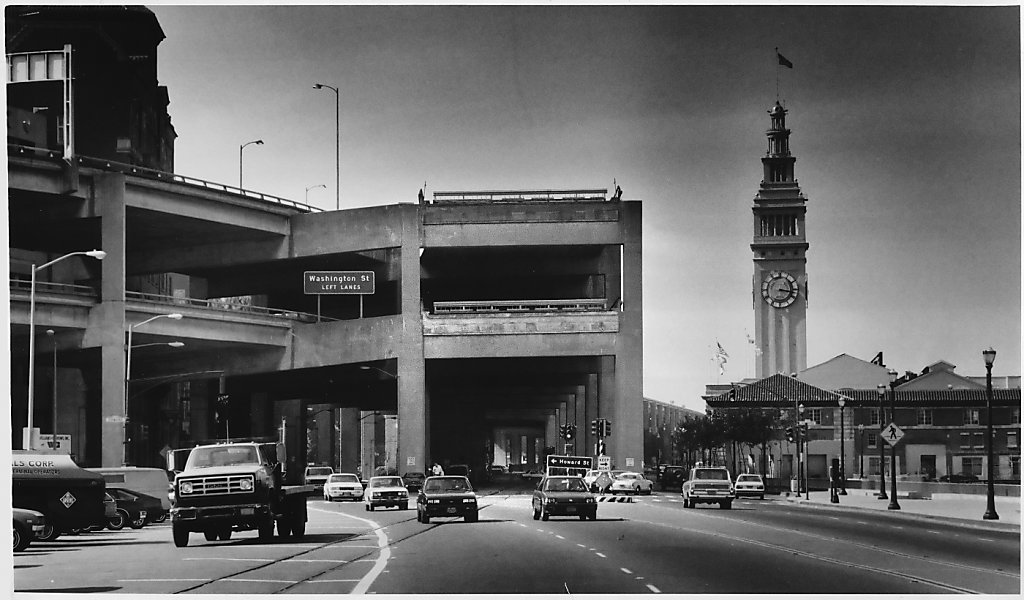
The Loma Prieta earthquake killed 63 people and injured 3,757 people. Much of the damage, and most of the deaths, involved the Bay Area’s elevated freeways. The double-deck Nimitz Freeway in Oakland collapsed, killing 42 people. A section of the Bay Bridge’s eastern span collapsed onto the lower deck, closing the bridge. Sections of San Francisco’s other freeways – The Embarcadero Freeway (SR-480), the Central Freeway (US 101), and Southern Embarcadero Freeway (I-280) did not collapse, but were structurally compromised by the quake.
BART was running again within hours of the quake, and proved to be an invaluable lifeline, running for 24-hour service for weeks following the quake, and together with ferries carrying tens of thousands more commuters each day than ever before. The Bay Bridge was repaired and reopened a month after the quake. Some of the earthquake-damaged freeways were temporarily reopened after the quake, but other sections remained closed to traffic. San Francisco had some profound decisions to make; repair or rebuild its damaged freeways, or choose a different future? The quake’s aftermath rekindled a civic debate that had mostly lain quiet since the Freeway Revolt decades before – what kind of City does San Francisco want to be, and what is the role of automobile in the City?
The First Freeway Revolt
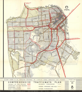 After World War Two, San Francisco, like other cities, made sweeping plans to adapt the city to mass automobility. The 1848 Trafficways Plan envisioned freeways throughout San Francisco. Freeways were bulldozed through neighborhoods. Residents in the path of the freeways organized and protested, and those protests grew stronger and more urgent as the freeway network expanded. Over 30,000 attended meetings and signed petitions in threatened neighborhoods. In 1959, to the surprise and chagrin of the State Department of Highways, San Francisco’s Board of Supervisors voted to cancel 75% of the proposed freeway routes through San Francisco. In 1961 the Supervisors cancelled plans for the Western Freeway through the Richmond and Sunset districts, and in 1966 the Supervisors, in a 6-5 vote, cancelled plans for a freeway through the Panhandle and Golden Gate Park.

The Freeway Revolt halted freeway construction in San Francisco, and for decades the City lived with the partial freeway network built in the 1950s, while freeway construction around the Bay Area and California continued.
In 1973, San Francisco adopted its first ‘transit first’ policy, and the City marked bus lanes on some City Streets. BART opened transbay service in 1974, and the Muni Metro light rail subway opened under Market Street in 1980. In the 1980s a proposal to remove the Embarcadero Freeway and replace it with a waterfront boulevard gained support. The growing dominance of container shipping had shifted maritime trade from San Francisco to Oakland, and removal of the freeway became part of plans to convert San Francisco’s historic but increasingly derelict piers into a vital public waterfront, and reconnecting the waterfront with the City. The Supervisors voted to remove the freeway in 1985, but the question was put to the voters in 1987, and was defeated.
San Francisco chooses a new road
The Embarcadero Freeway was badly damaged in the earthquake, and it was closed to traffic. The state’s highway engineers proposed replacing it, but Mayor Art Agnos championed removing the freeway and replacing it with a new waterfront boulevard. After months of debate, the Board of Supervisors voted 6-5 to remove the freeway. Demolition began in February 1991. Architect Dan Solomon observed:
On the night of 27 February 1991, the eve of its demolition, I walked the length of the top deck of the freeway … It was drizzling and dark, and it was like walking in Venice where the only sounds are footsteps and voices. For some reason there were lots of languages – Portuguese, German, Japanese, French, Chinese. People were silhouetted in the dark, just walking quietly, talking. As much as I had loved the views driving – ten thousand times, twenty thousand times, they were much more beautiful on foot, in the quiet.
On 27 February 1991 the automobile era ended. Now, even in California, people will talk about other ways to get around; about not having to get around so much: about towns, streets, public places, walking.
The Embarcadero Freeway was removed back to its junction with I-80, including a tangle of ramps around the Transbay Transit Terminal. The California legislature authorized turning over the state property under the freeway to San Francisco, and San Francisco agreed to fund completion and future maintenance of the surface roadways that replace the freeway.
The new Embarcadero boulevard followed the waterfront, and then turned southeast as King Street, which was widened into a boulevard after the earthquake. Removing an earthquake-damaged northern stub of I-280 freed the site where the Giants ballpark now stands, and new touchdown ramps were built several blocks east to connect the shortened freeway to King Street.
The northern end of the Central Freeway between Fell and Turk streets, including onramps from Turk and Gough and offramps to Franklin and Golden Gate, were closed after the quake, and demolished soon after. The remaining double-deck portion of the Central, connecting US 101 to Oak and Fell streets, needed repair but remained open to traffic while the City deliberated. The City appointed a citizen task force to develop and evaluate alternatives. The task force recommended that the freeway be demolished and replaced with a surface boulevard, and new freeway touchdown ramps built on the south side of Market. The task force were interested in removing the freeway further south of Market Street, both to avoid a freeway terminus on the City’s main civic boulevard and to take advantage of SoMa’s wider streets and long blocks to disperse some auto traffic, rather than concentrate it at a single intersection. Caltrans and the Mayor’s office forbade consideration of alternatives that removed or modified the steel portion of the freeway east of Mission Street, so the Market Street touchdown and Octavia Boulevard were recommended. Caltrans later closed the freeway west of Mission Street to remove the upper (southbound) deck. The traffic nightmare predicted by Caltrans and freeway boosters failed to materialize, strengthening the argument for freeway removal.
Pro-freeway activists and politicians put Prop K on the ballot in 1997, which called for retrofitting the freeway, and voters narrowly approved it. The following year, boulevard proponents put the boulevard alternative before the voters as Proposition E. Lawrence Ferlinghetti, then San Francisco’s poet laureate, gave a public address two weeks before the election, where he said
What destroys the poetry of a city?
Automobiles destroy it, and they destroy more than the poetry. All over America, all over Europe in fact, cities and towns are under assault by the automobile, are being literally destroyed by car culture. But cities are gradually learning that they don’t have to let it happen to them. Witness our beautiful new Embarcadero! And in San Francisco right now we have another chance to stop Autogeddon from happening here. Just a few blocks from here, the ugly Central Freeway can be brought down for good if you vote for Proposition E on the November ballot.
Proposition E was approved in November 1998. The following year there was a third referendum when freeway proponents revived the freeway retrofit proposal, and proposal was soundly defeated. The quake-damaged concrete portion of the freeway was demolished, and Octavia Boulevard and the new freeway touchdown ramps opened in 2005.