

By Marynoel Strope
Despite better-than-average bike infrastructure and public transit, cars are largely the mode of transport in San Francisco, and often the fastest and most accessible way to get around. It’s a reflection of the way our city’s infrastructure has shifted to serve the automobile first.
It wasn’t always that way. In fact, for most of the country’s history, communities were centered around other things – bodies of water, train stations, or communal gathering spaces like squares or marketplaces. In older cities, many of the roads we drive down today started as walking trails created over centuries by Native peoples.
New York City’s Broadway is one of the most famous examples, which began as a trail of the Canarsee Indians of the Lenape following a ridge and stretching from one end of Manhattan to the another.
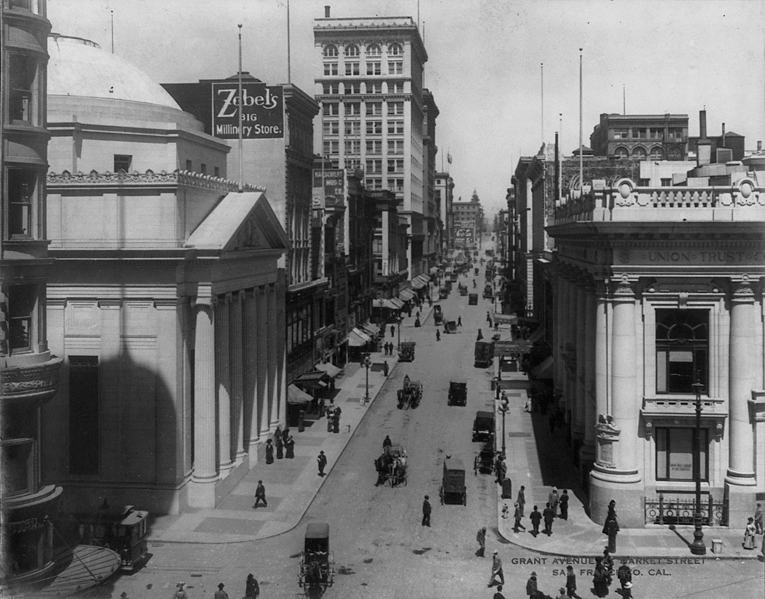
While human beings have been carving roads and paths for eons, it’s easy to forget that cars are quite new. Before automobiles, roads were shared spaces – open to pedestrians, vendors and modes of transport like horses and buggies. Children played in the streets freely and jaywalking just didn’t exist. Photos from the time show streets full of people and children traveling, eating, playing, socializing, shopping and crossing every which way.
The Automobile Land Grab & The Invention of Jaywalking
With the production of the first affordable, fast automobile – Henry Ford’s Model T- a calculated shift towards a car-focused society began to take place, spurred on by the automobile industry’s profit-seeking motives. Charles Hayes, president of the Chicago Motor Club, decided “it was time to target not the behavior of cars—but the behavior of pedestrians.”
A public relations campaign shaming jaywalkers (a newly-created term) and pedestrians placed the blame squarely on humans at a time when many were deeply troubled by the deaths caused by auto accidents. Interestingly, ‘jaywalker’ came from the word from the slang ‘jay’, meaning ‘ignorant bumpkin’. Before it was used to describe wayward pedestrians, the term actually described unruly drivers – “A jay driver is a species of the human race who, when driving either a horse or an automobile, or riding a bicycle on the streets, does not observe the rules of the road. It is the custom of the jay driver to drive on the wrong side of the street.”
The decade also saw the rise of planned “residence parks” – suburban-style neighborhoods like St Francis Wood – designed for drivers, not pedestrians. “Apartment houses, groceries, laundries, saloons, stables, or undertaking establishments” were not permitted in these decidedly non mixed-use communities, where wealthy residents were expected to drive to services and retail.
Invasion of The Freeway
By 1948, the city’s Trafficways Plan envisioned a city criss-crossed with eight freeways, from the Mission to the Sunset. Redevelopment was on its way as modernist architects and planners envisioned a car-dominated city of the future, where buildings were massive and set far back from the streets. Pedestrians were relegated to walkways, often above or below street level, and planners shifted land use to accommodate parking spaces and structures.
The most infamous redevelopment project was the razing of a 36-block zone in the Western Addition, a plan first submitted in 1947. The planning department’s intention was clear: to create a whiter, wealthier neighborhood from the dense, culturally thriving African American district (which was also one of the city’s most racially integrated and diverse), and demolish Victorian homes in favor of scattered large, setback developments.
“It was mutually-assured destruction,” Livable City Executive Director Tom Radulovich said of the new modernism. “Streets got more dangerous, and buildings withdrew from the street. It eroded city life.”
The plan decimated the community, including its world-class jazz scene, razing blocks of old Victorians and leaving empty lots in their place, some of which lingered into the 70s and 80s. Though residents were promised a right to return, few were actually given the option. The area’s significant Japanese population, who’d been forced out and placed in camps during World War 2, were paid tribute in a modernized Japantown, bordered by the brand-new, high-speed and highly unwalkable Geary Boulevard. But few people of Japanese descent moved back to the new area, with its stylized architecture, shopping malls and raised pedestrian walkways.
Today, San Francisco, like many American cities, still suffers the negative effects of the era’s redevelopment projects. Lower Fillmore Street, rebuilt with giant high-rises and large blocks of public housing, failed to provide the social cohesion – and even volume of housing – the old neighborhood had, and efforts to revive the commercial corridor continue to be a challenge, especially in an age of vast wealth inequality and racial disparities.
The Bayview also changed when the 101 freeway replaced the old Bayshore Highway, transforming a bucolic beachside neighborhood served by streetcars to a traffic thoroughfare. Though it’s home to the T, the city’s first light rail line in half a century, the line’s service has been spotty, failing to serve the area’s residents – many of them the descendants of African Americans displaced during Western Addition’s redevelopment. Other major traffic thoroughfares, like San Jose Avenue, are not freeways per se, but were established to cut through the city to accommodate cars, and are decidedly not pedestrian-friendly.
With their centrally located commercial corridors, walkable neighborhoods built in the pre-car era remain the most desirable today. Others, like Parkmerced with its high-rise clusters bordering high-traffic thoroughfares, show the legacy of modernism.
Developers still favor – and continue to build – giant, boxy high rises, but many of the large, bottom-floor retail spaces make up long-term vacancies, further eroding city life. Though malls like the Sunset’s Stonestown are losing anchor retailers, and Union Square is dotted with vacant buildings, a 250,000-square-foot mall was constructed on central Market Street in 2010 in an effort to revitalize the area. Today, the mall sits empty, anchored only by a parking garage.
Before cars took over the bustling city of San Francisco, people walked and used public transit to get around. A 1927 San Francisco study found that “streetcars were used by 70 percent of the people depending on some kind of transportation to get downtown, while only a quarter used passenger cars, but the latter made up 61 percent of vehicular traffic as compared to 11 percent for the streetcars”. The second level of the Bay Bridge was devoted to light rail, which came to a stop in 1958.
From Neighbors to Poet Laureates: San Francisco Fights The Car
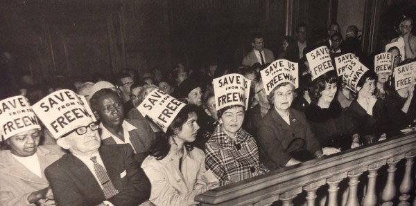
Photo: San Francisco Chronicle
Resistance followed redevelopment, and similar projects in the Mission were halted due to opposition. The resistance didn’t stop at car-focused city planning, though, and in the 1950s and 60s a series of protests known as the Freeway Revolt put a stop to the Trafficways plan.
Many people resisted automobile dominance. In the 20s, the San Francisco electorate twice defeated amendments to build underground parking in public parks. Still, the City pushed on, eliminating trolly and cable car lines in favor of the buses that get stuck in car traffic.
BART began providing an efficient public transit alternative to City buses in 1972, at time when more and more people were advocating for environmental sustainability. With only eight stops in San Francisco, the finished system was a far cry from the original proposal, which served far more SF neighborhoods, as well as Marin County. The following year, SFMTA adopted a “transit-first” policy it still has today, though few political leaders have signed on to make the policy a reality.
The 1989 Loma Prieta earthquake changed the landscape yet again, damaging both the Embarcadero and Central Freeways. While the waterfront-hugging Embarcadero Freeway quickly came down, the Central Freeway’s fate was unclear. Cycling and livability advocates were gaining steam, and the issue was put to the voters three times.
“What destroys the poetry of a city? Automobiles destroy it, and they destroy more than the poetry,” Lawrence Ferlinghetti said in his inaugural address as Poet Laureate of San Francisco in 1998.
“All over America, all over Europe in fact, cities and towns are under assault by the automobile, are being literally destroyed by car culture. But cities are gradually learning that they don’t have to let it happen to them.”
Ferlinghetti urged San Franciscans to vote to replace the Central Freeway with a boulevard. A Central Freeway Citizens Advisory Council was established, and ultimately, city street Octavia Boulevard replaced the big, bulky freeway’s right-of-way.
1999 saw the city’s first “road diet” on Valencia Street, transforming the street with new bike lanes and creating a model that would be followed, albeit piecemeal, in street improvements citywide. Widening sidewalks, adding bulbouts, greening with parklets, trees and plants and creating protected better biking and transit infrastructure have become the best practice to create walkable, bikeable streets.
Today, the movement to pedestrianise city streets and reclaim them from cars coincides with movements for transit, environmental and economic justice. After many years, Livable City’s fight to eliminate minimum parking requirements saw a victory this year. While cars still dominate – and the rise of TNCs have dumped thousands more daily on city streets – both major boulevard Market Street and the Mission’s Valencia are continually brought up as ideal streets for year-round car-free spaces. SFMTA has begun to study the feasibility of car-free streets that would be open to pedestrians, bicyclists and city buses. But such a shift to a multi-modal future isn’t easy.
“Optimizing streets for cars is pretty simple,” said Radulovich. “But if you really think multi-modal, you need a much more complex and nuanced vision. Cities are complex, and you have to approach them with a certain level of humility.”
Livable City Takes it To City Hall
- A Parking Reform Victory: Eliminating Minimum Parking Requirements
- Walkable 10-Minute Neighborhoods Mean Less Car Reliance: Rethinking Residential Zoning
- Great Transit Means Less Car Reliance, too!: Creating Sustainable Door-to-Door Transportation
- Zoning Reform for Better Retail Means Dense, Walkable Neighborhoods: Retail and the Livable City, Part 1 and Part 2
- Livable City’s work on Accessory Dwelling Units create a sustainable housing strategy that diversifies housing options and conserves neighborhood character